

Literature-based case study | side-scan sonar bottom tracking QC. Why do straight structures bend and near-nadir mosaics smear after automated SSS processing?
The practical question
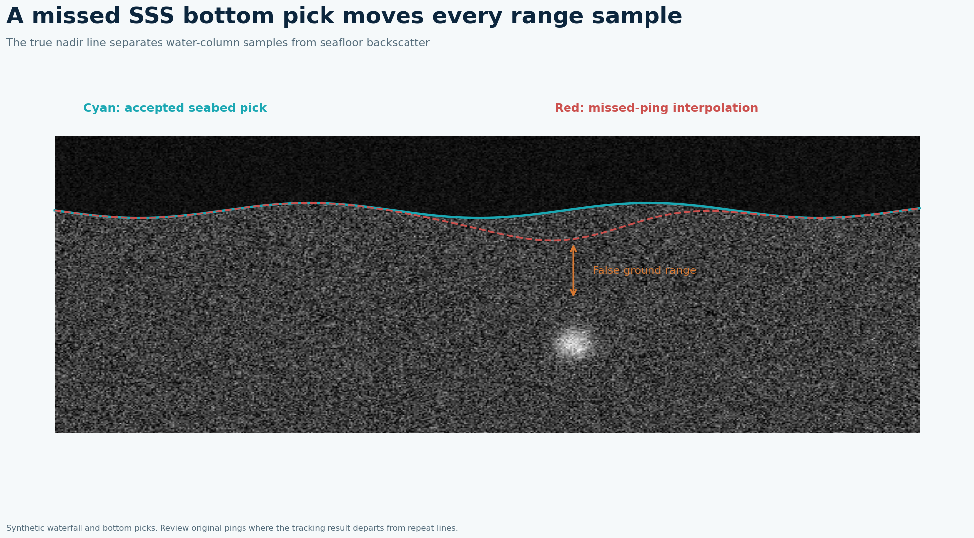
Slant-range correction requires the true first bottom return and sonar altitude. If a tracker mistakes water-column noise, an object highlight or a weak return for the seabed, every affected ping gets a wrong ground-range transform. A high average accuracy can still hide a contiguous bad segment directly over a cable crossing.
What the published data actually say
The reported validation used a 13,504-ping survey line and obtained 94.5% bottom-tracking accuracy with a 4.9% miss-ping rate. Source: Real-Time Bottom Tracking Using Side Scan Sonar Data Through One-Dimensional CNNs, Remote Sensing 2020. These are findings from that location and acquisition setup, not a GeoSubsea project or a universal equipment specification.
A defensible field-to-report solution
Plot port and starboard bottom lines on the raw waterfall and overlay altitude, pressure depth and vehicle motion. Automatically flag jumps beyond physically plausible altitude-rate changes, missing pings and prolonged disagreement between sides. Review contiguous flagged stretches manually, interpolate only short gaps with supporting neighboring data, and rescan long ambiguous gaps if the deliverable requires full coverage. Rebuild the mosaic and compare straight seabed features and reciprocal line overlaps. Keep the original waterfall for audit.
Worked decision example
At 4.9% of 13,504 pings, roughly 662 pings would be missed if that rate applied uniformly; this multiplication is illustrative and the paper’s metrics are not a line-by-line miss log. The spatial distribution matters much more: 662 isolated misses may be manageable, while one long gap across a hazard corridor demands intervention.
What to record in the field
A production tracker needs an exception process as much as an average score. Show every ping's candidate water-bottom boundary on the waterfall and mark sudden jumps, long missing runs, asymmetric port and starboard results and departures from the vehicle's depth-altitude record. Sample the manually checked lines across sediment types and sea states, with extra attention at acoustic shadows and near strong objects. A short isolated dropout may be interpolated with neighboring pings; a sustained uncertain segment should stay masked until a human checks it or data are reacquired.
How to make the engineering decision
After edits, regenerate slant-to-ground-range positions rather than merely painting over the mosaic. Compare repeat-pass locations of a recognizable linear feature and calculate the change in estimated fish altitude across edits. The paper's 94.5% bottom-tracking accuracy and 4.9% missed-ping rate refer to its validation line, not all future datasets. Acceptance for a cable crossing should also include a map of unresolved pings over the crossing itself. Provide edited picks and original sonar files so a reviewer can reproduce the corrected image geometry.
QC gates before accepting the interpretation
Publish a ping-level mask of accepted, edited and unresolved bottom picks. Do not use an aggregate model score alone as mosaic sign-off; verify the actual survey lines and target areas.
Limits and next action
The 94.5% and 4.9% figures are study-specific and their definitions should not be treated as interchangeable. For a project-specific decision, identify the required engineering tolerance, review the raw survey evidence and agree the validation method before acquisition or reprocessing.
Applied decision scenario
Suppose automatic bottom picks look plausible for most of a line but fail for 80 consecutive pings at a steep crossing. The missing run may represent a short distance or a significant corridor segment depending on speed and ping rate. Inspect the raw waterfall and fish altitude through that interval. If a manually traced bottom is defensible, document the correction and regenerate the ground-range mosaic. If not, mark the coverage hole and compare an offset line. A percentage score of the entire 13,504-ping study line cannot clear this particular crossing without local evidence.
Questions to resolve before sign-off
Why does a high tracking score still require manual review? A line-wide score aggregates thousands of pings, while the project decision may concern a few dozen at one crossing. Error can cluster on steep seabed, near shadows or in complex water-column returns. Plot failures geographically instead of reporting only a percentage. Should every failed ping be interpolated? No. Interpolate a short gap only if adjacent reliable picks and fish altitude support it. A sustained gap can shift a whole sequence of ground-range pixels. Mark it unresolved, compare a reciprocal line and consider resurvey. Deliver a coverage and exception layer with the mosaic so a clean image is not mistaken for complete evidence.
Related geophysical services
GeoSubsea supports integrated side-scan sonar, sub-bottom profiler, multibeam and high-resolution 2D seismic processing, survey QC and interpretation. For a defensible site-specific assessment, start with the survey objective, raw data, positioning records and ground truth.
Explore GeoSubsea services · More case studies
Primary reference
Real-Time Bottom Tracking Using Side Scan Sonar Data Through One-Dimensional CNNs, Remote Sensing 2020. The figures above are original editorial illustrations; they do not reproduce source figures.
Leave a Reply