
Comprehensive Marine Geophysical Data Processing and Interpretation Solutions
At GeoSubsea, we specialize in transforming raw marine geophysical and hydrographic data into accurate, reliable, and fully interpreted deliverables that meet international standards.
Our experts use industry-leading software and workflows to ensure your project data supports safe, efficient, and cost-effective offshore development.
1. Multibeam Bathymetry (MBES) Processing
High-precision bathymetric data processing for detailed seabed mapping and modeling.
We apply advanced filtering, sound velocity corrections, and tidal adjustments to create high-quality grids and DTMs (Digital Terrain Models).
Deliverables include:
- Cleaned and corrected MBES data
- Bathymetric grids and contours
- Slope and hillshade maps
- QA/QC and metadata reports
2. Side Scan Sonar (SSS) Mosaicking & Interpretation
We process and interpret side-scan sonar data to identify seabed features, sediments, and potential hazards.
Our mosaics are geo-referenced, balanced, and visually enhanced for clear seabed texture visualization.
Deliverables include:
- Geo-referenced sonar mosaics
- Object detection and contact charts
- Seabed classification and sediment interpretation
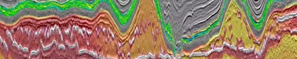
3. Sub-Bottom Profiler (SBP) & Ultra-High-Resolution Seismic (UHRS)
Accurate processing and interpretation of sub-seabed profiles for stratigraphic and geotechnical understanding.
Our workflows include deghosting, band-pass filtering, gain corrections, stacking, and horizon picking.
Deliverables include:
- Processed seismic sections (TIFF, SEG-Y, or PDF)
- Stratigraphic horizons and layer thickness maps
- Structural and geohazard interpretations
4. Magnetometer (MAG) Data Processing & Analysis
Precise detection and mapping of magnetic anomalies for UXO (unexploded ordnance), pipeline, or debris identification.
We use de-spiking, base station correction, and total field anomaly calculation methods.
Deliverables include:
- Magnetic anomaly maps
- Target coordinates and classifications
- Summary analysis and object list
5. Seismic Interpretation & Horizon Mapping
Comprehensive geological interpretation of 2D/3D seismic and UHRS data.
We define key horizons, faults, and geohazards to support offshore wind, oil & gas, and pipeline routing.
Deliverables include:
- Horizon maps and isopachs
- Fault interpretations
- Structural cross-sections and depth models
6. Integrated Geophysical Reporting
We combine all processed datasets into a complete geophysical interpretation report, aligned with client and industry specifications.
Each report includes data methodology, results, interpretations, and recommendations.
Deliverables include:
- Interpretation reports (PDF/Word)
- GIS-ready layers (shp, GeoTIFF, ASCII)
- Figures, charts, and metadata
7. GIS Integration & Visualization
We prepare all deliverables in GIS-friendly formats, compatible with ArcGIS, QGIS, and CAD platforms.
This allows for smooth integration into client engineering, environmental, or construction workflows.
8. Quality Control & Data Management
All projects follow strict QA/QC protocols at every processing stage.
We maintain clear traceability from raw data to final results, with version control and documentation.
Standards followed:
- IHO S-44
- IMCA S006
- ISO 9001 workflows
Why Choose GeoSubsea
✅ Proven experience in offshore energy and infrastructure projects
✅ Advanced data processing and visualization tools
✅ Timely, accurate, and traceable deliverables
✅ Multilingual technical communication and reporting
✅ Trusted by international developers and survey contractors
Ready to Work With Us?
Whether you’re managing an offshore wind farm, cable route, or marine engineering survey, GeoSubsea delivers the clarity you need below the surface.
📧 Contact us today: info@geosubsea.com
Request a detailed quote here: Detailed Quote