
Detecting Hidden Metallic Objects and Magnetic Anomalies Beneath the Seabed
At GeoSubsea, we provide advanced magnetometer data processing and interpretation to identify and map magnetic anomalies caused by buried metallic objects, unexploded ordnance (UXO), wrecks, anchors, pipelines, and cables.
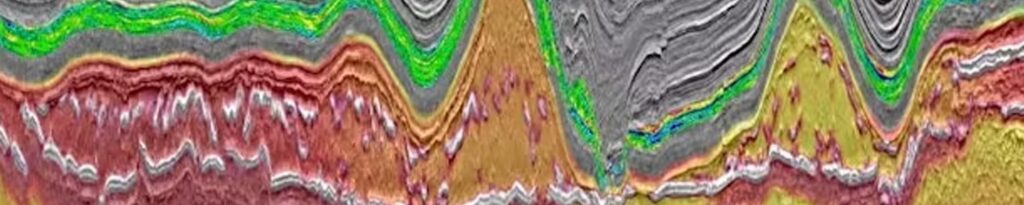
Magnetometer (MAG) surveys are essential components of marine geophysical investigations, particularly in UXO clearance, pipeline and cable route assessments, and marine archaeology.
Our geophysicists utilize industry-standard magnetic processing tools combined with in-house interpretation expertise to deliver high-accuracy anomaly detection and mapping, ensuring safe and efficient offshore development.
Purpose and Application
Magnetometers measure minute variations in the Earth’s magnetic field.
When a ferrous or magnetized object — such as an anchor, pipeline, or UXO — is buried beneath the seabed, it produces a localized magnetic disturbance that can be detected and mapped.
These surveys are critical for:
- UXO detection and risk mitigation prior to offshore construction
- Pipeline and cable route clearance surveys
- Anchor and debris location for infrastructure safety
- Wreck identification and archaeological studies
- Metallic infrastructure mapping (pipelines, subsea structures, or foundations)
By accurately detecting and classifying anomalies, GeoSubsea helps clients minimize operational risks and make informed engineering decisions in line with safety regulations and international standards (IMCA S006, IHO, and OSPAR).
Our Magnetometer Data Processing Workflow
Processing magnetic data requires careful correction and calibration to remove natural and instrumental effects, allowing the true magnetic anomalies to be clearly defined.
Our workflow is built upon proven geophysical practices and tailored for both single-sensor and gradiometer arrays.
1. Data Import and Quality Control
- Import of raw magnetic data files with associated navigation and timing information
- Synchronization between position data (DGPS/RTK) and magnetometer readings
- Inspection of signal stability, sampling rate, and data completeness
- Removal of spikes or erroneous readings caused by equipment noise, vessel movement, or interference
All incoming datasets are verified for acquisition integrity before detailed corrections are applied.
2. Base Station Correction and Diurnal Variation Removal
The Earth’s magnetic field varies naturally throughout the day due to solar and geomagnetic activity.
To eliminate these temporal variations, we apply base station correction or diurnal removal using reference data from nearby magnetic observatories or survey-specific base stations.
- Compute and subtract diurnal variations from each survey line
- Normalize total field readings to a common baseline
- Apply International Geomagnetic Reference Field (IGRF) model corrections to isolate local anomalies
This process ensures the resulting dataset reflects only local magnetic disturbances, not global or temporal field fluctuations.
3. Field Calibration and Compensation
To enhance data reliability, GeoSubsea applies calibration routines to correct instrument biases and environmental effects:
- Heading correction to compensate for orientation-dependent sensor bias
- Lag correction to align position and magnetic readings precisely
- Sensor offset correction for towed or gradiometer configurations
- Crossline comparison for repeatability and consistency validation
For multi-sensor arrays, we perform inter-sensor leveling and alignment, producing a stable magnetic field baseline across all channels.
4. Data Filtering and Enhancement
Once corrected, the magnetic data are filtered to enhance the visibility of significant anomalies while minimizing background noise.
- Low-pass and high-pass filters to separate regional trends from local anomalies
- Derivative and gradient filters to highlight sharp transitions
- Analytic signal and total field computation for improved anomaly shape definition
These enhancements allow accurate mapping of object signatures and help in differentiating between shallow and deep magnetic sources.
5. Anomaly Detection and Classification
Using both automated algorithms and expert interpretation, GeoSubsea identifies and classifies magnetic anomalies based on intensity, geometry, and pattern recognition.
- Detection of point-source anomalies (e.g., small UXO, anchors, or debris)
- Mapping of linear features such as pipelines or cables
- Calculation of magnetic dipole moments and gradient magnitudes
- Classification into categories such as ferrous object, cluster anomaly, or infrastructure-related source
Each anomaly is geo-referenced and assigned a unique ID, with measured attributes including peak intensity (nT), estimated size, depth estimate (if applicable), and confidence level (high, medium, low).
6. Target Mapping and Visualization
Detected anomalies are plotted and visualized in both plan-view and profile formats to support engineering interpretation.
- Magnetic anomaly contour maps and residual intensity grids
- Target position maps with confidence-coded symbology
- Anomaly intensity cross-sections for depth and geometry analysis
- Integration into GIS or CAD for overlay with other datasets (MBES, SSS, UHRS)
We ensure all maps and charts are fully geo-referenced (WGS84, UTM, or client-defined grid systems) and compatible with project GIS databases.
Deliverables
GeoSubsea provides a comprehensive deliverable suite designed for UXO specialists, engineers, and geophysicists to directly integrate into project workflows:
- Magnetic anomaly maps and residual field grids (GeoTIFF, PDF, or CAD format)
- Target coordinate lists with anomaly classification and confidence level
- Anomaly intensity charts and interpreted magnetic profiles
- Interactive GIS shapefiles or KMZ layers for client visualization
- Full interpretation and methodology report, including processing parameters, QC results, and conclusions
All deliverables are internally validated through peer review and QC checklists, ensuring data traceability and compliance with client standards.
Integration with Other Geophysical Data
For comprehensive site characterization, GeoSubsea integrates magnetic interpretation with other geophysical datasets such as Side Scan Sonar (SSS) and Sub-Bottom Profiler (SBP).
This correlation helps confirm object identity, position, and burial depth, providing a multi-sensor validation approach to anomaly detection.
Typical applications include:
- Correlating magnetic anomalies with SSS targets for UXO or debris verification
- Cross-referencing UHRS and SBP data to confirm buried object geometry
- Supporting risk ranking and clearance prioritization for offshore infrastructure projects
Why Choose GeoSubsea for Magnetometer Data Analysis
- Extensive experience in marine magnetic data interpretation for UXO, cable, and route surveys
- Processing workflows aligned with IMCA, OSPAR, and IHO standards
- Advanced use of gradiometer array corrections and noise modeling
- Integrated GIS-based deliverables for client-ready visualizations
- High precision, reproducible, and auditable outputs
- Responsive communication and bilingual technical reporting (English/Korean/Vietnamese)
From Magnetic Field to Meaningful Insight
At GeoSubsea, we turn raw magnetic data into actionable intelligence that helps safeguard offshore operations and infrastructure.
Through rigorous processing, careful classification, and integrated interpretation, we ensure every anomaly is identified, analyzed, and mapped with precision.
📧 Contact us at info@geosubsea.com to learn more about our Magnetometer Data Analysis services or to request a demo dataset.