
Imaging Beneath the Seabed with Ultra-High Precision
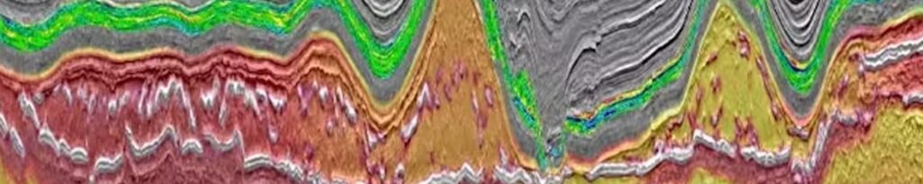
At GeoSubsea, we specialize in advanced Sub-Bottom Profiler (SBP) and Ultra High-Resolution Seismic (UHRS) data processing and interpretation, providing a clear window into the subsurface layers of the seabed.
These datasets are fundamental for understanding geological stratigraphy, sediment characteristics, and potential geohazards that can influence offshore foundation design, cable routes, and engineering decisions.
Our geophysicists combine years of offshore experience with industry-leading software tools such as RadExPro, Kingdom, and Geosuite to deliver scientifically robust and visually clear subsurface models.
Purpose and Application
SBP and UHRS systems transmit controlled acoustic pulses into the seabed and record reflected signals from sedimentary layers and buried structures.
This technology provides vertical profiles of the sub-seabed, allowing our clients to:
- Identify stratigraphic boundaries and layer continuity
- Detect buried channels, paleo-valleys, or gas pockets
- Map sediment thickness and geotechnical layering
- Assess seabed stability for turbine foundations or pipeline routes
- Evaluate potential geohazards such as shallow gas, faults, or hard layers
Whether your project involves offshore wind, subsea cable installation, dredging, or oil & gas exploration, GeoSubsea’s SBP/UHRS services provide the subsurface clarity you need to make confident engineering decisions.
Our Data Processing Workflow
Our SBP and UHRS data processing workflow is built on international best practices (IMCA, IHO, ISO) and refined through years of field experience. Each stage is designed to maximize signal clarity, enhance true reflections, and ensure data consistency across survey lines.
1. Data Preparation and Quality Control
- Importing raw SEG-Y data and validating navigation files
- Checking acquisition parameters (shot interval, gain settings, sample rate)
- Synchronizing time and position channels for precise spatial accuracy
- Identifying data gaps, timing errors, or misfires
2. Pre-Processing and Noise Suppression
- Trace editing to remove dead or unstable channels
- De-spiking and swell noise removal to stabilize amplitude variation
- Band-pass filtering to isolate optimal frequency ranges for target resolution
- Deghosting and water column muting to eliminate multiple reflections and ringing effects
3. Amplitude and Phase Optimization
- Automatic Gain Control (AGC) to balance amplitudes across traces
- True Amplitude Recovery (TAR) to maintain realistic signal strength
- Phase correction and spectral balancing for improved vertical resolution
4. Velocity and Stack Processing
- Velocity analysis and correction based on sediment acoustic properties
- Trace stacking to enhance signal-to-noise ratio and emphasize reflectors
- Migration to correct for dipping structures and improve reflector geometry
5. Horizon Picking and Interpretation
- Identification and digitization of key stratigraphic boundaries
- Structural mapping of reflector terminations, channels, and discontinuities
- Correlation of features across survey lines to generate 3D subsurface understanding
- Calculation of isopach (layer thickness) and sediment volume maps
6. Quality Assurance (QA/QC)
At each stage, data undergoes rigorous visual inspection and statistical QC, including amplitude histograms, time slices, and frequency spectra, ensuring the final outputs meet GeoSubsea’s strict accuracy and reliability standards.
Integration and Interpretation
Once processed, SBP and UHRS datasets are integrated with other geophysical and geotechnical data such as MBES, SSS, CPT, and borehole logs to build a holistic subsurface interpretation.
Our interpreters work closely with engineers to define the upper stratigraphic units (e.g., Holocene, Pleistocene) and their mechanical properties — supporting foundation design, trenching analysis, and burial assessments.
Interpretation outputs include:
- Stratigraphic unit definition and correlation
- Identification of erosional surfaces, faults, or hard layers
- Geohazard assessment (gas pockets, pockmarks, voids, buried objects)
- Sediment volume estimation for dredging or trenching operations
Deliverables
At the end of the project, clients receive a comprehensive package of fully processed and interpreted products, ready for engineering and reporting use:
- Processed SEG-Y and TIFF sections (raw and final versions)
- Geo-referenced interpreted profiles in PDF and GIS formats
- Horizon and isopach maps showing sediment distribution and structure
- Stratigraphic correlation charts and subsurface cross-sections
- Full technical report detailing processing methodology, parameters, QC results, and interpretation conclusions
All deliverables are prepared to align with client specifications and can be integrated into CAD, GIS, or 3D visualization environments.
Why Choose GeoSubsea
- Proven experience in UHRS processing for offshore wind, UXO clearance, and pipeline surveys
- Multi-software compatibility and customized workflows per survey configuration
- Bilingual reporting (English/Korean/Vietnamese) for international collaboration
- Strict quality control and documentation from raw data to final interpretation
- Fast turnaround and responsive communication with your technical team
🌍 Clarity Beneath the Waves
At GeoSubsea, our goal is simple — to help you see what lies beneath with absolute confidence.
Through meticulous SBP and UHRS data processing, we deliver subsurface models that reduce uncertainty, improve safety, and enhance your offshore project planning.
📧 Contact us today at info@geosubsea.com to discuss your SBP or UHRS data processing requirements.